Click on the icons on the map to reveal some of its
characteristics.

Information

Source

Image
Painting or Map
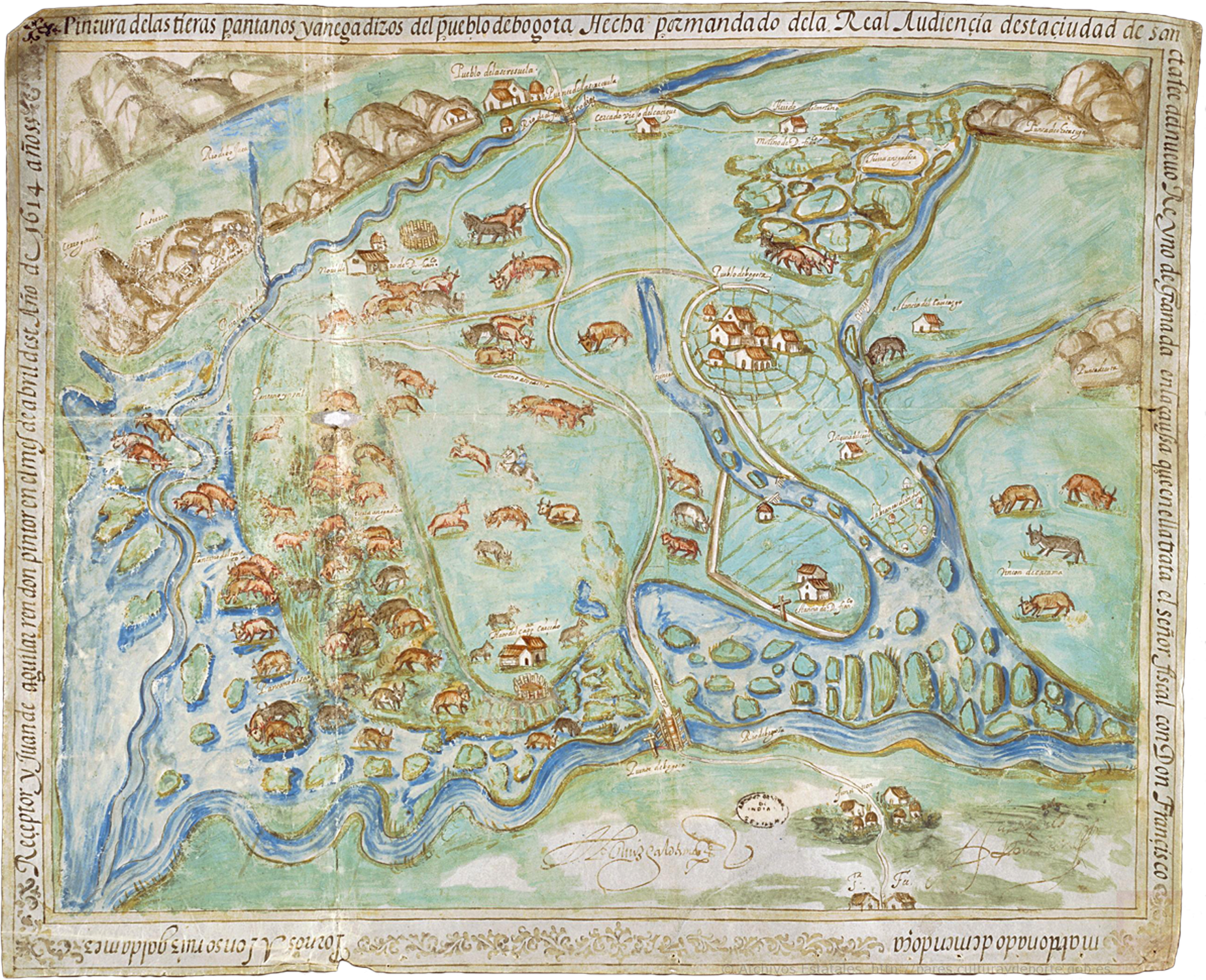
This canvas from 1614 belongs to two different genres:
landscape painting and map. Although it was made to serve as
evidence in a legal trial over land ownership, the
manuscript is not a simple outline, as used to be the case
with maps at the time. Instead, it delves into the artistic
terrain with its singular use of color, its elaborate
designs and the inclusion of the signature of the author,
Juan de Aguilar Rendón. These three elements tell us that
the author was interested not only in showing the
distribution and use of land for the trial, but also in
creating a piece that could be appreciated for its aesthetic
qualities.
Dispute over Lands
In 1603, Francisco Maldonado y Mendoza was accused of having
defrauded the monarchy by buying large and fertile terrains
at a very low price, and was taken to court. The purpose of
the painting was to illustrate the land to allow the court
to judge if the accusation was true or if Maldonado was
right in claiming that the land was nothing more than a
barren wasteland. Annotations such as “useless marsh” or
“swamp land” were fundamental to the development of the
trial. The court ruled in favor of Maldonado and ratified
his rights over these terrains.
The Village of Bogotá
Although Colombia’s capital was known for a long time as
Santafé de Bogotá, on the painting we find two different
places: the “village of Bogotá” (today the town of Funza)
and the “city of Santa Fe” (today Santafé de Bogotá). This
is due to the fact that the creation of villages was a
policy designed to instate two different republics,
spatially distinct and with different legal
responsibilities: one republic for Indians living in
villages and one for Spaniards living in cities. The
separation of the two republics was never fully achieved in
practical terms because villages had very active economies
involving Spaniards and mestizos, and also because many
natives lived in cities.
African Grass
With the introduction of cattle raising in the Bogotá
Savanna, the landscape was modified to fit the interests of
cattle farmers. The grasslands depicted in the painting,
therefore, are likely not of the same kind that cover the
savanna today. In the eighteenth century, ranchers
encouraged importing African grasses that provided better
yield for cattle raising. The introduction of African
grasses in the New World, nevertheless, can be traced back
to an earlier date, when they were used in making the beds
in ships for the slave trade.
Land Dispossession
On the painting we can see a dramatic reduction in the area
occupied by native farmlands, in comparison to the vast
pasture lands of the hacienda of Spaniard Francisco
Maldonado y Mendoza. In this sense, this document is
essentially a map of land dispossession, and of the
transformation of the agricultural landscapes of native
societies.
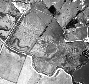
Ridge System
Before the arrival of the Spanish and the introduction of
their methods of farming and breeding, the Muisca that
inhabited the region organized and made use of water sources
through the ridge system. This system consisted of raised
platforms that served as terraces for growing food. They
were traversed by levees that brought many benefits, such as
draining excess water so that the terraces could be sowed
and serving as fishing channels.
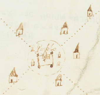
Villages for the Indians
The villages depicted on the map, such as Fontibón or La
Serrezuela, were built as part of a project with which the
Spanish Empire sought to compel natives to live Catholic
lives and to “forget their former rites and ceremonies”. As
a result, natives were forced to abandon their homes and
resettle in villages organized around a main square and a
church, and drawn as a grid. This process was known as the
“reduction” of the natives.
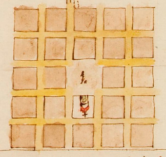
the scale of the map
Unlike modern maps, which ensure accuracy by maintaining a
constant scale throughout the image, the Painting uses a
multiple, flexible and variable scale. The center of the map
—which represents the territory in dispute between Maldonado
and the crown attorney— uses a more precise scale, while the
edges are much more variable, allowing the observer to see
relatively remote landmarks, like the city of Santafé and
the towns of Fontibón and Madrid.
the colors of the map
Although we do not know the origin of the paints used on the
map, the production of inks and colors was a complex craft
involving vegetable and animal pigments that were then
transformed into paint through processes with rich cultural
significance. We have evidence that the Muisca and other
native groups used a wide palette of blue, red and brown
pigments they applied to designs on textiles, rocks and
other surfaces. For this reason, it is possible that some of
the colors used on the Painting were native paints.
Cattle in the Americas
Throughout Antiquity and the Middle Ages, Spain developed a
cattle culture around the raising of cows, sheep, goats and
pigs which depended on the use of horses and dogs to control
livestock that was allowed to roam freely. After being
introduced into the New World, these species quickly
flourished, easily adapting to an environment lacking in
natural predators. Meanwhile, other less wanted species such
as the Norway rat, which had come on the ships of the
settlers, also multiplied.
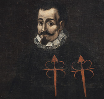
Francisco maldonado y mendoza
Maldonado y Mendoza was born in Spain in 1551 and moved to
Santafé de Bogotá in 1583. In 1586 he married Jerónima de
Orrego, daughter and sole heiress of conquistador Alonso de
Olalla. That year, Maldonado y Mendoza began buying estates
in the Bogotá Savanna and receiving lands awarded by the
Spanish Crown. By the mid-1590s, Maldonado y Mendoza was not
only the encomendero of the indigenous community of Bogotá,
but owned one of the most prosperous cattle haciendas of the
New Kingdom of Granada. On the painting, we find evidence of
this in the depictions and labels of some of the spaces of
the hacienda: Mill of Don Francisco, steer yard of Don
Francisco, estate of Don Francisco, and so on. His heirs
held on to his power and wealth for over two centuries.
City of Santafé
This map/painting depicts the Bogotá Savanna, a high plateau
on the Eastern Range of the Andes in present-day Colombia.
In the early sixteenth century, the Savanna was occupied by
Muisca indigenous people, of the Chibcha linguistic family.
A Spanish expedition led by Gonzalo Jiménez de Quesada came
to this place in 1536. The city of Bogotá would then become
the center of operations of the Spanish Empire in the area,
and in 1549 it was declared as the seat of the Audiencia of
Santafé.
Old Palisade of the Cacique
When the Spanish arrived, the Muisca were organized in
farming societies with many levels of political hierarchy,
and its leaders lived in ceremonial places surrounded by
logs of wood and decorated with paintings on cotton fabric
of different colors and styles.
Road as Ridge
The map labels the road as a “ridge”. This particularity
reminds us of the fact that many native and colonial roads
in the Savanna were built as raised platforms so that they
would remain dry in rainy seasons. To this day people call
many tracks and roads in the Savanna “ridges”.
Pigsty of the Cacique
Native societies in the New World had domesticated many
animals, among which dogs, turkeys and ducks. In the
Peruvian and Bolivian Andes, they also raised camelids such
as lamas and alpacas, used as pack animals and for their
wool. The inclusion in the map of the pigsty and the grazing
land of the cacique proves that natives also integrated
European animals into their economic activity. This was the
case with chickens and sheep, the latter used for their wool
in order to replace cotton and produce blankets at a lower
cost.
Claims of the Natives
“[…] we come before you to state the troubles and
destructions we have suffered in our town in the form of
damages to our crops. There is a neighbor named Agustín Vela
with over two hundred mules and horses, bovine cattle and
donkeys in our reservation. Before we can harvest our misery
which is wheat, maize, barley and truffles, he brings in his
tame and wild mules and destroys [our crops] having many
lands […] maliciously fattening his mules with our grain
[…]” Natives of Turmequé, 1672.
Construction of Villages
“The buildings of the village should be built in such a way
that the square is placed in the middle in reasonable
proportion, and from it, all streets should branch out with
their building lots according in number to the amount of
inhabitants, and the building lots and houses will be of a
size, with their yards […], so that first and foremost the
villagers can join in building their Church on one side of
the square, the altar facing east and of a grandeur and size
proportional to the village and somewhat larger, and on the
other side build the house of the cacique and lord with
reasonable grandeur, and on the other side the house of
their cabildo and the jail, and on the other, the houses of
the nobles, and behind them, along the roads, the rest of
the building lots […]” Tomás López Medel, 1559
Natives in the City
“Having understood the disorders and excesses seen in this
city of Santafé de Bogotá due to male and female Indians,
mestizos, and mulattoes that are without a master to serve
and for this reason are found idle and like vagabonds, which
often results in grave damages and problems […] and wanting
to provide aid to this as you see fit so as to put an end to
such disorders […] I name him administrator of the said
Indians and mulattoes […]” Instructions for the
Administrator of Indians of Santa Fe, 1594.
Francisco Maldonado de Mendoza
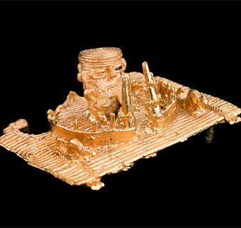
Votive figure in goldsmithing (Muisca)
Aerial photo of a ridge (1956)
Village of Suta
Village of Guasca
Click on the icons on the map to reveal some of its
characteristics.
Browse the map and zoom in and out to see more details.
This is the Painting of the Land of Bogotá laid over a
present-day map of the area. The overlay is approximate, given that
the scales of the painting and the present-day map do not fully
coincide.
This is a skewed version of the
Painting of the Lands of Bogotá we put together to show the
difference between the scale it used and the scale we use today.
This is how the Painting would look if we made its scale to
coincide with the scale of our present-day map.